
Whether you are a tourist, backpacker, enthusiast, or explorer, if you are hunting the best hikes in the Maryland area, you are on the right track. In this whole article, you will find top hikes in Maryland that are loaded with thrill, breathtaking experiences, long walks, adventures, historical events, and whatnot. So, let’s look at these best hikes and learn more about them.
Is there good hiking in Maryland?
Yes, fortunately! You will find many hikes in Maryland that are extremely adventurous, full of elevations, unique traversing experiences, topographies, and everything you were looking for. This state offers fresh air to make your hiking experience more beneficial.
What is the scariest hike?
Talking about the spooky hikes in Maryland, one can not forget to mention Paw Paw Tunnel. With 6 billion bricks and more than a decade of construction, this hike is unique and filled with historical events. It is situated near the corner of Green Ridge State Forest in Oldtown, Maryland.
[elementor-template id=”13257″]
10 Best Trails and Hikes in Maryland
To enjoy life to the fullest in Maryland, you can explore some cool, long, and great hikes in this state. These are the best of both worlds, as they allow you to enjoy mountain biking, horseback riding, fishing, hiking, and much more.
1. Sugarloaf Mountain Maryland
It is a pet-friendly trail, allowing you to spend an entire day doing mind-relaxing activities like birding, hiking, and walking.
If you want to meet with the best natural surroundings and beautiful views, reach Sugarloaf Mountain, a popular hotspot for tourists and locals. This trail is famous for mind-blowing scenic views where you can capture sunset pictures and make your evenings memorable.
You can add Sugarloaf Mountain to your Maryland’s must-watch places. Also, be sure to plan essentials according to this fascinating place and add them to your moving to Maryland checklist. According to Wikipedia, this mountain has an elevation of 1,283 ft. and is situated in Frederick County, Maryland.
The entire route of this trail is moderate and challenging, taking 1 hour and 45 minutes to complete.
How long does it take to climb Sugarloaf Mountain, Maryland?
3.5 miles only! The entire Sugarloaf Mountain is a 3.5-mile-long hike that will take more than an hour to explore.
Can you drive to the top of Sugarloaf Mountain, Maryland?
Yes, undoubtedly! This entire trail allows you to drive and reach almost the top of the mountain. You can capture the mesmerizing Montgomery and Fredrick County views from this point.
2. Catoctin Mountains Maryland
This mountain range is home to timber rattlesnakes, black bears, turkeys, deer raptors, and vultures. Similarly, the presence of oak, hickory, ash, maple, and cherry trees makes this place ideal for your hiking points. Looking for another best hikes in Maryland area?
Try the Catoctin Mountains, which are unexpectedly beautiful and mind-refreshing. This hike has a special place in most visitors’ hearts due to its natural presence. Catoctin Mountains are famous for its hiking trails, Misty Mount cabin camping, Poplar Grove Youth Groups Sites, and many more attractions.
According to Maryland Government, this mountain has an elevation of 1,870 feet. It is also considered one of the most challenging and moderate routes in Mayland for hiking.
Where are the Catoctin Mountains in Maryland?
These mountains are located at 6602 Foxville Road, Thurmont, Frederick County, Maryland – 21788.
Why is Catoctin Mountain closed?
Due to security issues, most parts of Catoctin Mountain are closed. But the best thing is that a few portions are open for everyone, where folks can see some interesting mountainous views and spots during the year.
Are there bears in the Catoctin Mountains?
Yes! This entire Catoctin Mountain is surrounded by a forest area where you can see a black beer. However, you need to be fortunate enough to see this animal.
Is Catoctin Mountain part of the Appalachian Trail?
Yes! This part belongs to the three miles of the Appalachian National Scenic Trail.
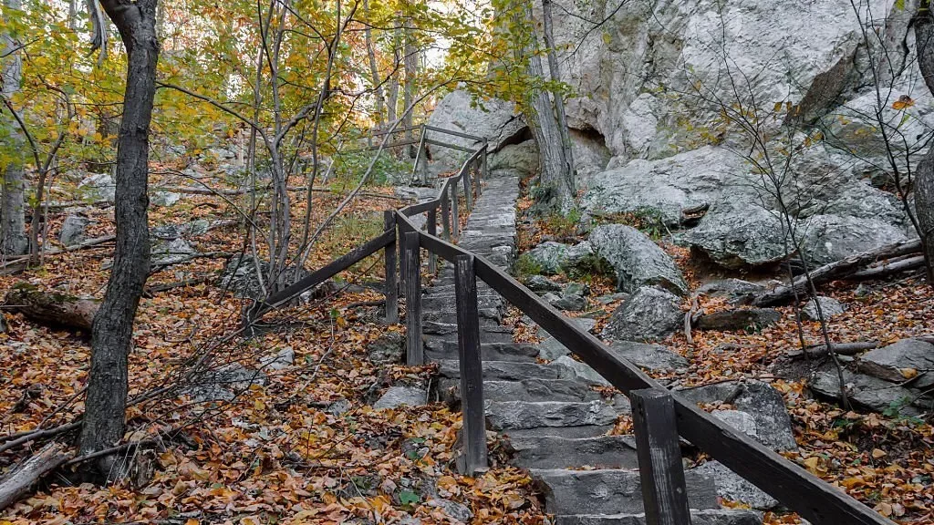
3. Annapolis Rock Maryland
Leaving hiking activity, you can climb the Annapolis Rocks in this area. Note that you will find adventurist groups exploring the entire place. But it is perfect for picnickers, bird watchers, photographers, and others.
If you are looking for the best hikes in Maryland with dogs, try this long hike with serene views of Greenbrier Lake and Cumberland Valley from the top. This is famous for exploring the white-blazed Appalachian Trail and blue-blazed Spur Trail near the campground.
According to the Maryland Hikes, this entire Annapolis Rock has an elevation of 1700 feet that takes almost 2.5 hours to complete. Further, this entire place is easy to hike, providing excellent surrounding views.
How long of a hike is Annapolis Rock?
It is a long trail of 5.3 miles with dirt & rock trail terrain you can access without a fee.
Is Annapolis Rock Trail open?
Yes! You can experience this thrilling rock trail at any time throughout the year.
[elementor-template id=”13252″]
4. Cascade Falls Loop Trail
This entire loop trail is ideal for mountain biking, hiking, and running because of the soothing waterfalls. On top of that, this whole place is unique, kid-friendly, and pet-friendly. In our list of best Maryland hikes, Cascade Falls Loop Trail is one of the best trails to explore with your families and ideal for a one-day picnic.
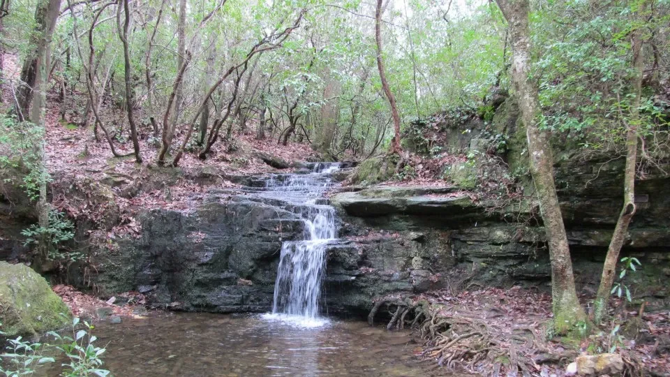
This entire trail is famous for its natural environment, waterfalls, and fresh air. You can bring your friends and pets to traverse this popular trail, making your day-out mesmerizing. With an elevation of only 377 ft. and three miles to explore, it is easy to explore the entire trail.
Where do you park for the Cascade Falls trail?
The visitors can park their vehicles at the Landing Road parking lot or within the park. The park has free parking for everyone.
Where do you park for Cascade Falls, MD?
The Landing Road parking lot and a parking lot at the north end of the Cascade Falls are available on this premises to safely park your vehicles.
How long is the Cascade Falls trail Patapsco?
This entire trail is about 2.3 miles long out-and-back trail for everyone, taking a few minutes to complete.
5. Great Falls Overlook Trailhead
In this Great Falls, you will get three viewing points, allowing you to get different views of this trailhead. And the cherry on top is that handicapped folks can access Overlook 2 & 3. If you are a resident of Maryland but moving from Maryland to Florida for the best hikes, this will be a bad decision for you.

You can explore the entire great Falls Overlook Trailhead in Maryland, with stunning adventurous activities, eateries, and spectacular surrounding towns. This whole place is famous for its natural ambiance, road biking, running, hiking, and eye-catching views.
Therefore, this is one of the most preferred choices among the locals. With around 4.7 miles of the hike, it only has an elevation of 193 ft., and it is moderate to explore the entire trail.
Where is the best view of Great Falls?
You will get a pleasant view from point Overlook 3, which shows the best views of Great Falls and is accessible by trail.
How long is the Great Falls Billy Goat Trail?
This entire trail is 4.8 miles, taking more than one and a half hours to complete.
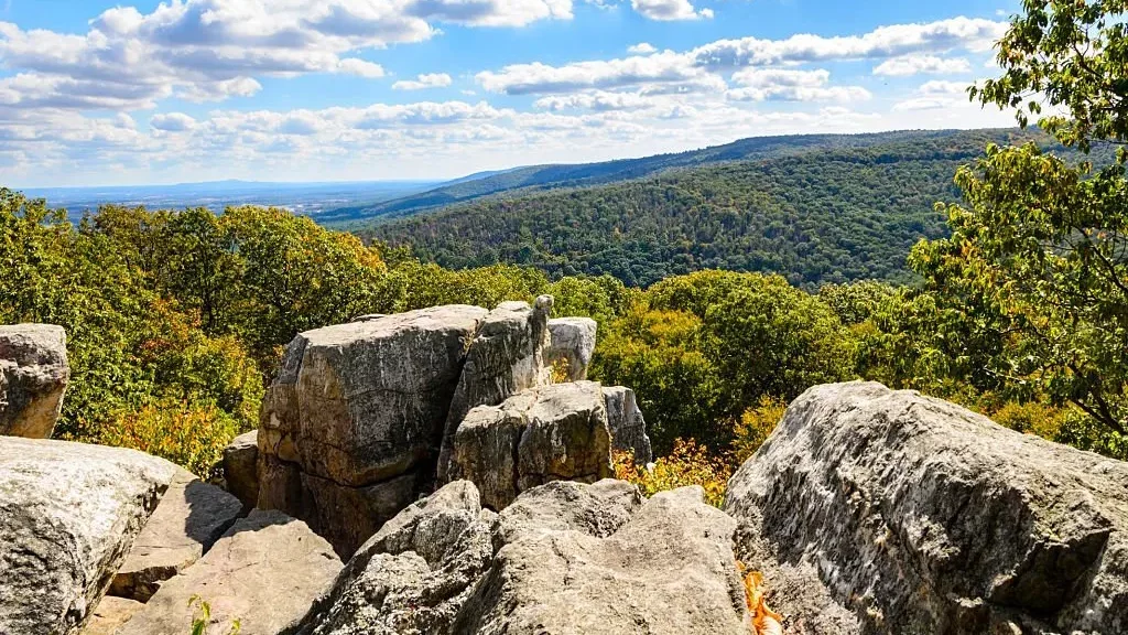
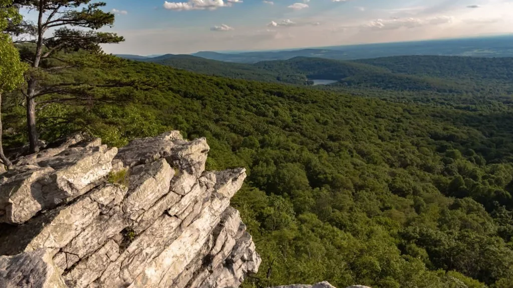
6. Wolf Rock/Chimney Rock Loop Trail
You will find it challenging to hike on these trails on cold days because of fog. But the surrounding destinations like Visitor Center and Park Headquarters are outstanding to explore and provide great views. In our list of Maryland hikes, we have the sixth trail of Wolf Rock/Chimney Rock Loop, filled with incredible panoramas.

Despite these panoramic views, you can enjoy climbing on its great rocks. Furthermore, these rock formations are popular for enjoying lunch and the green scenic beauty around you. The view from the top is just pleasurable and enticing.
You can reach the top of Wolf Rock, which has an elevation of 1419 ft., taking around 2 hours or more to complete. However, the route is moderate and accessible throughout the year.
Where is Catoctin Mountain Park?
This adorable nature venture at Catoctin Mountain Park is situated at 6602 Foxville Road, Thurmont, Maryland 21788.
Why is Catoctin Mountain Park closed?
Due to stormy weather conditions, most terrains of this park stay closed in winter, which may disappoint winter trekking lovers.
Is there a fee for Catoctin Mountain Park?
No! This whole place is freely accessible, even if you don’t need to pay for entrance.
7. Avalon Loop Trail
This entire loop trail offers beautiful nature vibes where you can stay close to nature and spend your day bird watching, hiking, mountain biking, and many more. With the blend of waterfalls, historic structures, and a peaceful walkable background, this Avalon Loop is definitely a great pick for your hiking experience.
It is one of the most popular trails in Maryland, offering everyone a pet-friendly environment, natural greeneries, and a true hiking experience. With an elevation of 686 meters, this entire route is about 32.2 kilometers long and is moderate to explore.
And the best thing is that you will find the best banks in Maryland near this Avalon Loop Trail. If something unusual happens, you do not have to worry about cash.
Where is the best view of Avalon Loop Trail?
The Cascade Falls area is the best viewpoint of this Avalon Loop Trail, providing fantastic and mesmerizing sceneries to everyone.
How long is the Avalon Loop Trail?
This trail is about 20.4 miles long. Therefore, cyclists can also explore this fascinating trail.
8. Swallow Falls Canyon Trail
Swallow Falls is accessible to your pets throughout the year, excluding the Memorial Day and Labour Day weekends. With a wonderful surrounding waterfall and a long trail covered with trees, this Swallow Fall Canyon Trail is all set to give you a heaven-like feeling.
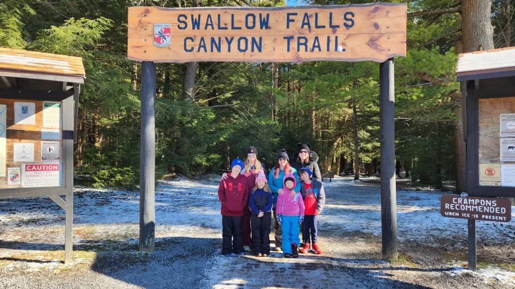
This entire location is perfect for giving you an unforgettable walking journey experience and is one of the best hikes in Maryland. This place is often considered one of the most popular trails in Maryland due to its full nature vibe views, waterfalls, and long walking paths.
With an elevation of 42 meters, this entire canyon trail is about 1.8 kilometers long that takes about half an hour to complete. Similarly, the route is moderate to explore.
How much does it cost to get into Swallow Falls State Park?
The entrance price varies according to season. However, a person must pay about $3 if he is a Marylandian. Otherwise, the fixed charge is $5 for outsiders.
Is Swallow Falls an Actual place?
Yes! With breathtaking scenic views and unbelievable locations, Swallow Falls is situated at 2470 Maple Glade Road, Oakland, Maryland – 21550.
How many waterfalls are in Swallow Falls State Park?
Three waterfalls are available in Swallow Falls State Park: Upper Falls, Lower Falls, and Tolliver Falls. All these waterfalls have different sizes and exceptional views.
[elementor-template id=”13247″]
9. Calvert Cliffs Red and Orange Loop Trail
The entrance charges are five dollars for locals and seven for out-of-state travelers. However, the trail is blessed with 600 species of fossils, like seabirds, whales, sharks, and rays. Calvert Cliffs Red and Orange Loop Trail are among the best hikes in Maryland with dog accessibility.
Therefore, you can easily take a long walk with your pet on this loop trail. The entire area is famous for birding, fishing, and hiking. Therefore, you can easily spend some quality time with your favorite people and explore this entire state. With an elevation of 299 feet, this trail is often described as easy to explore that takes almost 2 to 3 hours to complete.
How long is the walk at Calvert Cliffs?
Calvert Cliffs are around 5.0 miles long that take a few minutes to complete, and you can explore some boardwalk sections over here.
Is Calvert Cliffs open to the public?
Yes! People can explore this entire park and trail from sunrise to sunset throughout the year.
Is Calvert Cliffs worth it?
Yes! This place is worth visiting with a hiking trail, hunting activities, a pleasurable park experience, and a few more awesome destinations.
Can you swim at Calvert Cliffs?
Yes! Calvert Cliff has a beach that allows you to swim.
10. Chesapeake And Ohio Canal Trail To Great Falls Overlook
The whole place is heaven for an adventure lover as Chesapeake & Ohio Canal allows you to hike, cycle, climb, kayak, canoe, ride horseback, rock scramble, and whatnot. Due to this, the whole place is full of adventure lovers, trekkers, and explorers.

This one is a point of attraction for every tourist out there because it is one of the best hikes in Western Maryland that was used as a means of transportation. It is famous for an out-and-back trail consisting of an enticing waterfall and a spectacular atmosphere.
This whole trail is about 297.2 kilometers long, takes 10 to 15 days to complete, and has an elevation gain of 324 meters, according to Hiiker.App. However, you may find this entire route with dirt, but it is easy to explore and full of adventures.
Where does the Chesapeake and Ohio Canal start and end?
It starts in Washington, DC, and ends in Cumberland, Maryland. However, this canal allows visitors to walk, run, and bike.
How long is the Chesapeake and Ohio Canal Trail?
The trail is about 184.5 miles long and filled with adventures.
Why was the Chesapeake and Ohio Canal important?
From 1831 to 1924, this entire canal was used to transfer coal to a few important parts of the USA, including West Virginia, Columbia, Georgetown, etc.
Where does the C and O canal trail start?
With numerous access points, this C and O canal trail starts from Georgetown on 29th North NW.
Best Hikes in Maryland FAQs
How long is the Calvert Cliffs hike?
Calvert Cliff is a 13 miles long trail situated beside the Chesapeake Bay coastline and around 4 miles of the out-and-back Red trail. You will find a beach at the end of the Red trail that comes with ancient fossils, including sharks to hunt.
What is the longest trail in Maryland?
With 297.2 kilometers and breathtaking adventures, Chesapeake and Ohio Canal Towpath is the longest train in Maryland. It starts from Cumberland, Maryland, to Washington, DC. However, you can also find some short hikes in Maryland.
What hiking trail has the most deaths in Maryland?
The Paw Paw Tunnel has the most deaths in Maryland. Although the tunnel takes you to the historical chapters, the past fierce events converted into violence and deaths. It is also assumed that spirits haunt the tunnel. Therefore, exploring this tunnel in daylight is the best option you can choose.
Conclusion
The article is filled with extreme, adorable, pleasant, and incredible nature experience hikes. These best hikes in Maryland area keep you away from that city’s traffic hustle where you can simply relax and feel nature. Furthermore, these hikes are able to refresh your mind by providing appealing panoramic views.
In addition, you will find a perfect combo of waterfalls and animals in these hiking locations, making your eyes standstill. Despite that, you can enjoy a long list of activities on these hikes, including mountain biking, horseback riding, cycling, and much more.
Due to this, your entire experience will be lit, and you will surely love them from the bottom of your heart. To learn more about long paths, fees, elevation, and natural presence, read the article again and get all the details within a few minutes.
[elementor-template id=”13242″]